Blue Runnings

Race Reviews, GPX files and more from North-East England

Lacing Up For Myself

I went to parkrun this weekend – my third of this year. I’m trying to make exercise a regular part of my life again as I continue working to improve my health; and because I’ve genuinely missed it. I’ve been going back to Bounce classes for a few months now, and in the last few weeks have even been back on my boots instead of trainers. I’ve just started going to weekly weight training classes with a friend at the local gym, but running seems the slowest to follow. The very bleak January and February of cold, dark, rain and wind are probably significant contributing factors! There’s not been many of those crisp and cold winter days I used to love being out in.

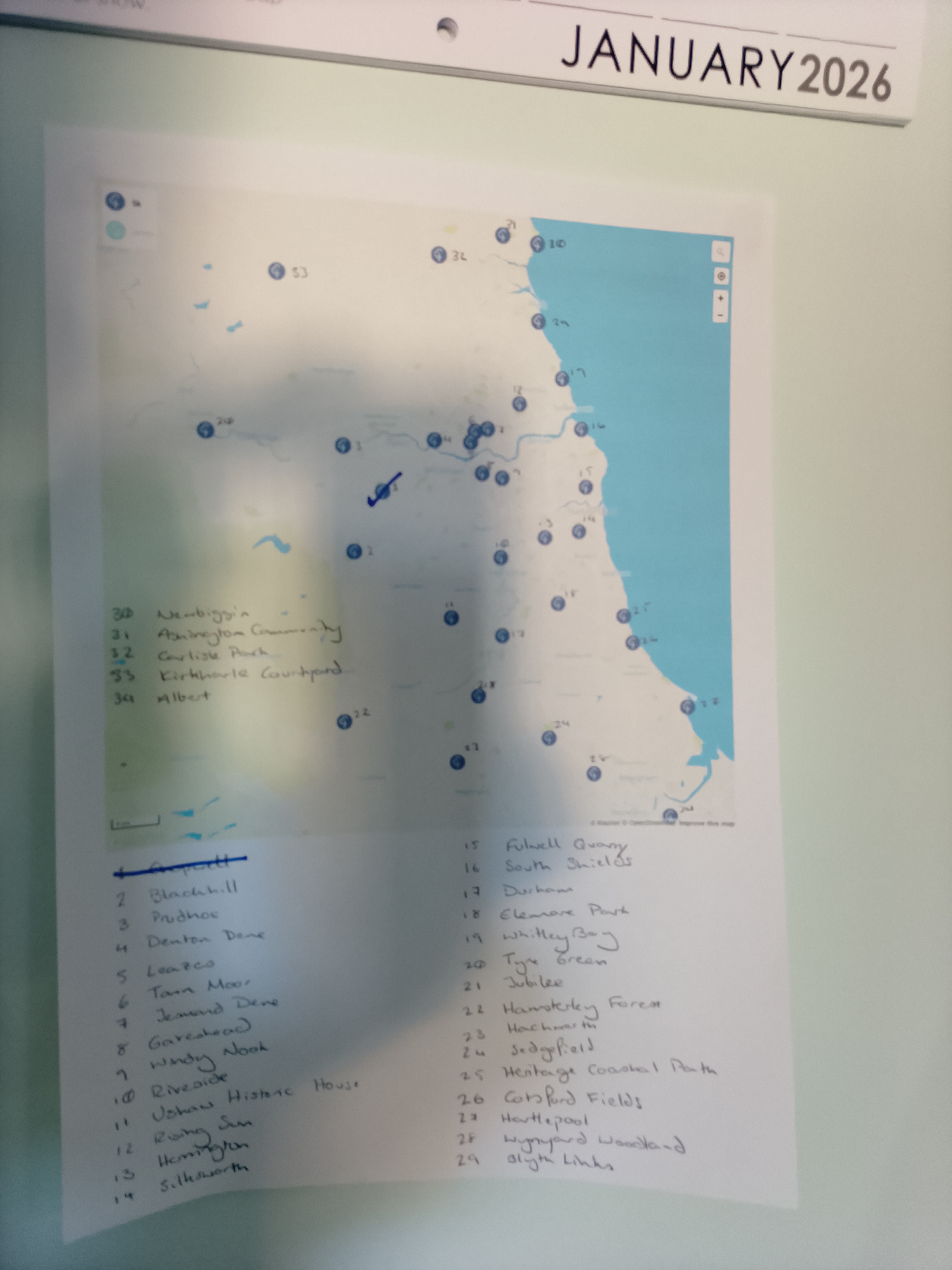
At the start of the year, I printed a map of the parkruns available in the North-East with the idea of giving myself a bit of variety and tracking which ones I ticked off in 2026. I enjoy Chopwell Woods, and last year was going to Denton Dene to ‘work up to’ going to Chopwell again (honestly, I don’t know why – I don’t think it’s any easier), but this weekend decided as the newest North-East parkrun at Ushaw Historic House was closed, I would bite the bullet and tick off Blackhill.

Looking at my parkrun results after the event, it was 2019 when I last attended Blackhill parkrun – despite it being my most-attended venue overall, and as I shuffled my way around it was clear to me why. The route has changed slightly since I last showed my face here, now starting with a nice downhill to the bandstand before heading up on a more gradual but longer uphill to the ‘theatre’ section of the park, but those three longer loops are just as they always were. Each, in isolation, not too bad – plenty of flat sections between the uphills and a long down at the end of each one. However, three is too many. I used to say I only went to Blackhill because I always forgot it was three laps instead of two and that still rings true. While it was good to pass so many familiar faces so many times, by the end of the second lap I was patting the Wishing Stone before the long downhill asking for ‘survival’ before turning to the final one.

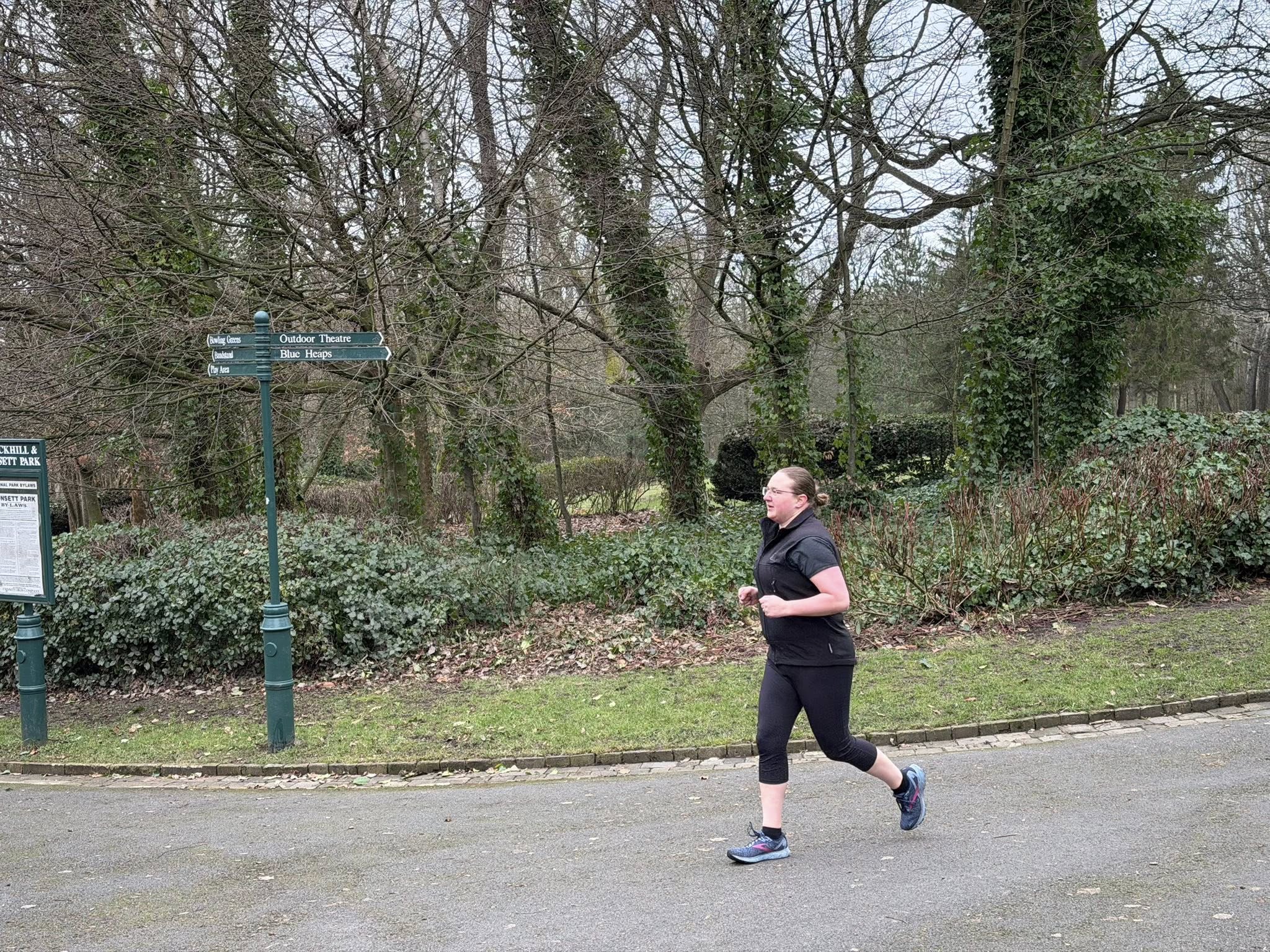
This is the first event of any type I’ve been to in a very long time where there’s been someone taking photos of the runners – and while there’s definitely no flying feet and I’m still not as fit as I’d like to be, I deliberately hunted the pictures down to have a marker of where I’m coming from at the start of 2026. My once mile-eating pace is still hiding in there, albeit with substantially less stamina than it once had (a metre-eating pace perhaps?), and despite being very much done by the time I crossed the finish line and scanned my tokens, it was good to be out again.

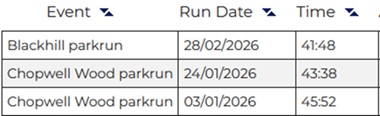
I’ve been leaving my watch behind for exercise sessions for quite a while now, preferring to go purely on how I feel and how I’m breathing and to be able to enjoy a session for itself without that glance at the screen at the end undermining the mental pace feeling. As such, any parkrun results come in later by text message when I’ve had a chance for a wash and a cool-down. I’ve been creeping my way down below the 45min mark, and been hoping over the next few months to see something starting with a 3X. I did not attend Blackhill with any aims other than ‘get around’, so it was a pleasant surprise when the text message landed to find that not only did I get around in 41m48s – faster than I’d thought by at least 5 minutes – I actually beat my time at Chopwell a few weeks earlier by 2 minutes and I’d argue Blackhill is the tougher course. That may only be in my mind. That thirty-something may be in reach sooner than I’d thought if I keep showing up for myself, especially if I stop always choosing hilly courses…

I even have a few running events booked for 2026 so determined am I to find my running gait again, the first being the Cockfield Chase fell race in April, and I’m daring to hope if I keep plodding on regularly I’ll not only be fit enough to attend but also be able to enjoy it without turning into a jelly blob at the finish. I’m not pushing the distances, but I do want to get back on the trails and be able to share my race experiences here again; which needs me to be out and completing them!

The weather is improving, the days are longer at both ends of the clock, and it’s getting easier to get out for walks or runs as well as rolling out the door for classes.

See you out there!

Sarah

x

Leave a comment »

parkrun – Durham

For information on this parkrun course, see the official parkrun page below:

http://www.parkrun.org.uk/durham/

This is a single-lap parkrun – not a huge number of those about! It’s quite out and back loopy, and covers a mix of terrains – we ran on gravel paths at the start, the outside of the rugby fields (stay outside the paint marks!) and onto the riverside path for a long stretch up to the bridge and back along the other side to the finish at the pavillion.

Durham had pacers for the event I went to, and I got the impression this was a moderately regular occurrence. I was trying to beat the 30min pacer, and while I’d left him a comfortable distance behind after the first mile, he was right behind me just before I came across the bridge – but the pace variance was me not him! He was bob-on for the 30 min marker 🙂

There’s plenty of parking at the sports centre near the start, as well as toilets and a track if you fancy a warm-up lap, but the finish is literally about 0.75 mile from the start. I’d pushed myself to get round in the time I wanted and was ready for a rest when I’d finished but when walking it felt like a loooong way back to the car. It is a pretty little woodland walk, and I did see a weasel, which was cool, but factor it in for your times if you’re in a rush to get home afterwards!

My GPS map for this route:

Durham

You can download the GPX route file for this course from my Dropbox account by following the link below:

GPX file for Durham parkrun

Course first completed 23-06-2018

Leave a comment »

parkrun – Pennington Flash

For information on this parkrun course, see the official parkrun page below:

http://www.parkrun.org.uk/penningtonflash/

This parkrun involves three laps of a small part of the grounds at Pennington Flash. There’s one hilly bit – not too long – and the rest definitely counts as ‘undulating’ to flat; not the flattest I’ve done but a long stretch from hilly. It’s worth noting that there is a reasonable walk from the carpark – allow 5-10 mins, and there is a parking charge at the main carpark (it’s a good size though – you should find a space fine). There is a free carpark at the entrance to the park, but it’s 1 mile walk/run from there to the start line, so factor this in if you’re planning on taking that option. Toilets available at the carpark and a lovely spot for birdwatching after your run!

30821794_2042586912623193_8143611890015744067_o

My GPS map for this route:

Pennington Flash

You can download the GPX route file for this course from my Dropbox account by following the link below:

GPX file for Pennington Flash parkrun

Course completed 21-04-2018

Leave a comment »

parkrun – Sedgefield

For information on this parkrun course, see the official parkrun page below:

http://www.parkrun.org.uk/sedgefield/

This parkrun in Sedgefield involves 2 laps of Hardwick Park; it’s mostly flat and runs around a lake but has one small hill about 2/3’s of the way round – fine on the first lap, a bit of a stickler on the second I found! There was plenty to see on the way round – a mix of wildlife and more manmade things of interest so it’s an easy one to just kick back and enjoy if you’re not going for a time 🙂

There’s plenty of parking – normally a charge but if you put your spare barcode in the windscreen it’s FREE until 11am, which gives you plenty of time to pop to the loos (also open before the start) and go the coffee shop for a breakfast bap or a wide selection of yummy cakes!

My GPS map for this route:

Sedgefield

You can download the GPX route file for this course from my Dropbox account by following the link below:

GPX file for Sedgefield parkrun

Course completed 14-04-2018

Leave a comment »

parkrun – Woodbank

For information on this parkrun course, see the official parkrun page below:

http://www.parkrun.org.uk/woodbank/

This parkrun in Stockport covers ground in two parks – Woodbank and Vernon, and starts at the top of a hill…you can see where this is going?! There’s a tough little uphill kick at the end of the Vernon Park loop (which you do twice) as you can see on the elevation profile below!

There’s limited parking near the start-line – maybe 20 cars? – so get there early if you’re planning on using it, or there’s a bigger public carpark nearby. Average number of runners is 120 per week, so no fear of being on your own in a small group of elite runners! The whole route takes place on tarmac, except for one small section of cobbles as you crest the top of the hill coming out of Vernon Park.


My GPS map for this route:

Woodbank

You can download the GPX route file for this course from my Dropbox account by following the link below:

GPX file for Woodbank parkrun

Course completed 31-03-2018

Leave a comment »

400dpiLogo

Hello! Welcome to Blue Runnings.

I run distances between 5k and half marathon, predominently around the North-East of England over a mix of terrains. I prefer trail and coastal runs, but you’ll also spot me at a few road runs if the setting’s right! If you’re looking for reviews of a particular race, please check the link below (or on the right) for a full list of races I have participated in and reviewed since 2015. These include GPX files, maps and elevation data.

Race Reviews

I am also an erratic attendee of various parkrun events; if you’re looking for information relating to the parkruns I have attended, please see the separate link below.

parkrun

You can keep up with the latest site updates, or just what I’m doing from my own fitness perspective on my facebook page – I regularly run (obviously!), cycle (badly!), hike and attend local Kangoo Jump classes. Irregularly, I’ll try whatever’s going!

www.facebook.com/bluerunningsNE

New for 2019 – an Excel sheet available to download to help you keep on track with your mileage targets; whether you’re running, walking, cycling, swimming, kayaking, you name it. I used a much more clunky version when I was trying to hit 500 miles in 2018 and tidied it all up nice and pretty for you. You can download it from my Dropbox account by the link below, or from the menu on the right 🙂

Mileage Tracker

Please get in touch either through the comments, the contact form or my facebook page if you’ve got any questions or feedback, I’d love to hear from you.

Sarah

Leave a comment »

parkrun – Divonne Les Bains – Lac de Divonne

For information on this parkrun course, see the official parkrun page below:

http://www.parkrun.fr/lacdedivonne/

This is a completely flat course (seriously, flat as a crêpe!), right on the border of France and Switzerland. The course is a there-and-back route covering three sides of the local lake with a very long narrow loop at one end. When I went all the marshalls spoke both French and English, and the kick-off instructions were given in both languages.

Local facilities:

  • Parking (free)
  • Café
  • Toilet (beware for those not acquainted with this type of toilet – the whole room is sprayed after use so do not follow someone straight in without waiting for it to do its cleaning cycle first or you will get a very unpleasant surprise!!!)
  • Play area

My GPS map for this route:

Lac de Divonne

You can download the GPX route file for this course from my Dropbox account by following the link below:

GPX file for Lac de Divonne parkrun

Leave a comment »

parkrun – Gibside

For information on this parkrun course, see the official parkrun page below:

http://www.parkrun.org.uk/gibside/

This is a tough little course – which was evident from the smaller number of runners who braved it despite it being a clear and sunny morning (though that may also have been the summer holidays coming into play). It’s a tough little course with some long and serious hills and an elevation of 311ft according to my GPS watch. There’s flatter stretches at the top of each hill, but you don’t get to go down much until the very end where you come right back down and then along the long flat of The Avenue back to the finish. You leave by the Walled Garden, head out on a loop at the top of the estate, and finish on a there-and-back part way up the hill to the highest point on Gibside’s grounds before spinning round and heading back to the Walled Garden again for the finish.

You can view a map of the estate (which is worth a visit even just for a walk round and a teacake) by clicking the link below.

Gibside Estate Map from National Trust

Runner’s View video tour of Gibside parkrun, taken 29-07-17 with a head-mounted (and therefore somewhat bouncy-recording!) Apeman camera.

Local facilities:

  • Café (takes cash or card)
  • Toilets

My GPS map for this route:

Gibside.png

You can download the GPX route file for this course from my Dropbox account by following the link below:

GPX file for Gibside parkrun

Leave a comment »

parkrun – Newcastle: Rising Sun

For information on this parkrun course, see the official parkrun page below:

http://www.parkrun.org.uk/risingsun/

This is a pretty flat course on tarmac country lanes and very well marshalled. You head out, do a repeat loop of about half a mile around the outside of a field at one end and then return back to the start.

Local facilities:

  • Café (takes cash or card)
  • Toilets

My GPS map for this route:

Rising Sun

You can download the GPX route file for this course from my Dropbox account by following the link below:

GPX file for Rising Sun parkrun

Leave a comment »

parkrun – Guildford

For information on this parkrun course, see the official parkrun page below:

http://www.parkrun.org.uk/guildford/

This route involves 2 laps of Guildford’s Stoke Park – and is rather more undulating than you might think at first glance, especially by the second lap!

There’s a communal parkrun coffee session at the bowling club just pass the treetop adventure course (try it if you’ve not already had your morning fill of fun?!) and Spectrum is just across the road for Costa and plenty of parking.

My GPS map for this route:

Guildford.png

You can download the GPX file for this course from my Dropbox folder here:

Guildford parkrun GPX file

Leave a comment »