Firstly, ‘flummoxed’ is an excellent word.
I am fortunate enough to live a stone’s throw from the countryside, and I decided today instead of always following the road routes that usually tie-in with bits I’ve done with Run England or join onto driven bits, I’d try mapping a route over the fields and go for more of a trail route and hopefully find a new short-ish multi-terrain route to train over without having to drive somewhere. Seems a bit of a waste of fuel driving somewhere when you’ve got fields and woods visible from the house and yet I never go there!
I had a look on the Ordnance Survey website – check out all these lovely paths to choose from over the fields!
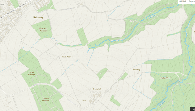
I picked a nice circular route, which when I put it on MapMyRun (which doesn’t show the paths on the maps but you can see them in aerial view) was a nice 3 miles from start to finish and had plenty of options for extending it in the future if I wanted to.
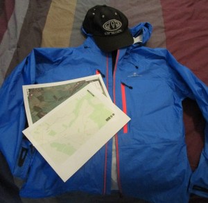
I was feeling all prepped for the slightly muggy day – I’d printed my maps out just incase I got a lost in the maze of tiny paths – there’s a few parallel ones etc. (not that it would have really mattered – I was never going to be hugely far from home). My parents got me a breathable fancy waterproof jacket for my birthday which I hadn’t really had opportunity to wear yet, so with risk of showers and not wanting to risk a cold I thought I’d wear that and a hat 🙂 All set and ready to go! Or so we thought…
I got less than half a mile out (having slipped in a very slap-stick-esque manner on the first stile to get into the first field) before being faced with this:

That grass track you see is from me going out a few steps and back again. The Earth has reclaimed the land! There’s also absolutely no sign of the stream that was showing on both maps… I’d gone through nearly knee-high grass and thistles to get to here, and already had cold and very wet feet! They warmed up as I got jogging again. I headed to the left of this stile along what looked like a viable track (for 20 yards anyway) and it rapidly became apparent I was probably following a deer trail – it went through a fence without any gates or stiles or people-typical crossing means. Eventually after tripping over tree roots and under branches for not very long at all, it disappeared altogether and I decided I would try and pick up the road track I knew I was originally intending to return along and do most of the loop in reverse, even if it meant going a bit further out towards Leadgate and back along the roads to get home rather than along the lack-of-path I’d found which would be the most direct route.
I followed the horse-trails to get back to the road (ending up climbing over a fence as the stile to the path was in the adjacent field which didn’t have an opening onto the one I was in and lots of barbed wire along the boundary!) and headed off down it. I’ve walked down this one before – there’s a pig sty I always check to see if I can spot the pig, but I’ve only spotted one on the first trip – but I’d never gone down to the bottom. It opens out into a cow field. In this case a cow field containing lots and lots of very interested cows with calves.
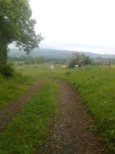
Even I can spot that path, but I know while a lot of cows are accustomed to walkers, and I’ve personally never had any bother from them, but I wasn’t sure how they would be with joggers and I’d walked a fair amount in the fields already with the rough ground and long grass, so I cut my rather poor attempt at a run short and headed back up to the main village again!
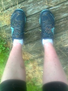
I ended up doing 1.5 miles instead of my planned 3, and my socks were about 4x heavier than when I’d put them on from all the water they’d absorbed! I think we’ll try this one again in the winter when I might be able to figure out where I’m going and there’ll be no young livestock about – it can be my own personal cross-country training course!
The red line is my intended route, and the blue one is where I actually ended up going…the Southern-most point is where I ran out of footpath, I then bimbled East and North following animal tracks, and the furthest East point is where the gate to the cow field is!

I don’t think I’m ready to be a self-sufficent route-planning fell runner yet! I definitely want to go further out along the cow road – the East-to-West top line as I think that’s a more major (existant) path, and I think I’ll be able to follow that and do most of the route in an anti-clockwise direction, and if necessary go further along to pick up a path off Pithouse Lane to get back to the top of the hill again. We’ll get there! I finished looking like I normally do after a winter run – wet feet, muddy legs and very pink thighs from cold and damp trousers! Bath time!


Leave a comment