Blue Runnings

Race Reviews, GPX files and more from North-East England

And It All Went Downhill From There… Washington Trail 5k

I would like to start by saying the described series of poor decisions and unfortunate events to follow are in no way representative of the race organisers, the race marshalls, the hosting facilities, or anyone other than myself and my own foolishness, with the inevitable consequences of such.

My sister and I have been working through a Garmin Couch to 5k plan with Jeff Galloway since December last year. The end delayed somewhat by various infections and viruses. We booked the Washington Trail 5k as our culminating event, as I’ve done the 10k several times and enjoyed it. Fen and I have gone somewhat off Jeff as his belief in you to complete the event seems to decrease with time even if you weren’t due and therefore haven’t missed a workout in between. This is not exactly good for morale, but I will cover the plan separately to this. It is mentioned here only as a stage-setter (and a grumble).

Jeff’s confidence 2 days before the race – which dropped to yellow again the day before!

I have also, after a history of bursitis in the knees and more recently athlete’s foot (despite not being an athlete – you don’t come here for clean and shiny do you?!), been working on improving my very flat arches and general foot strength by going around barefoot in the house and also recently purchasing some minimal trainers. I’ve only worn these once or twice on short drill sessions and know I haven’t quite got my gait right yet for faster than walking around: hello heel impact!

Decision 1 – Race Day Footwear:

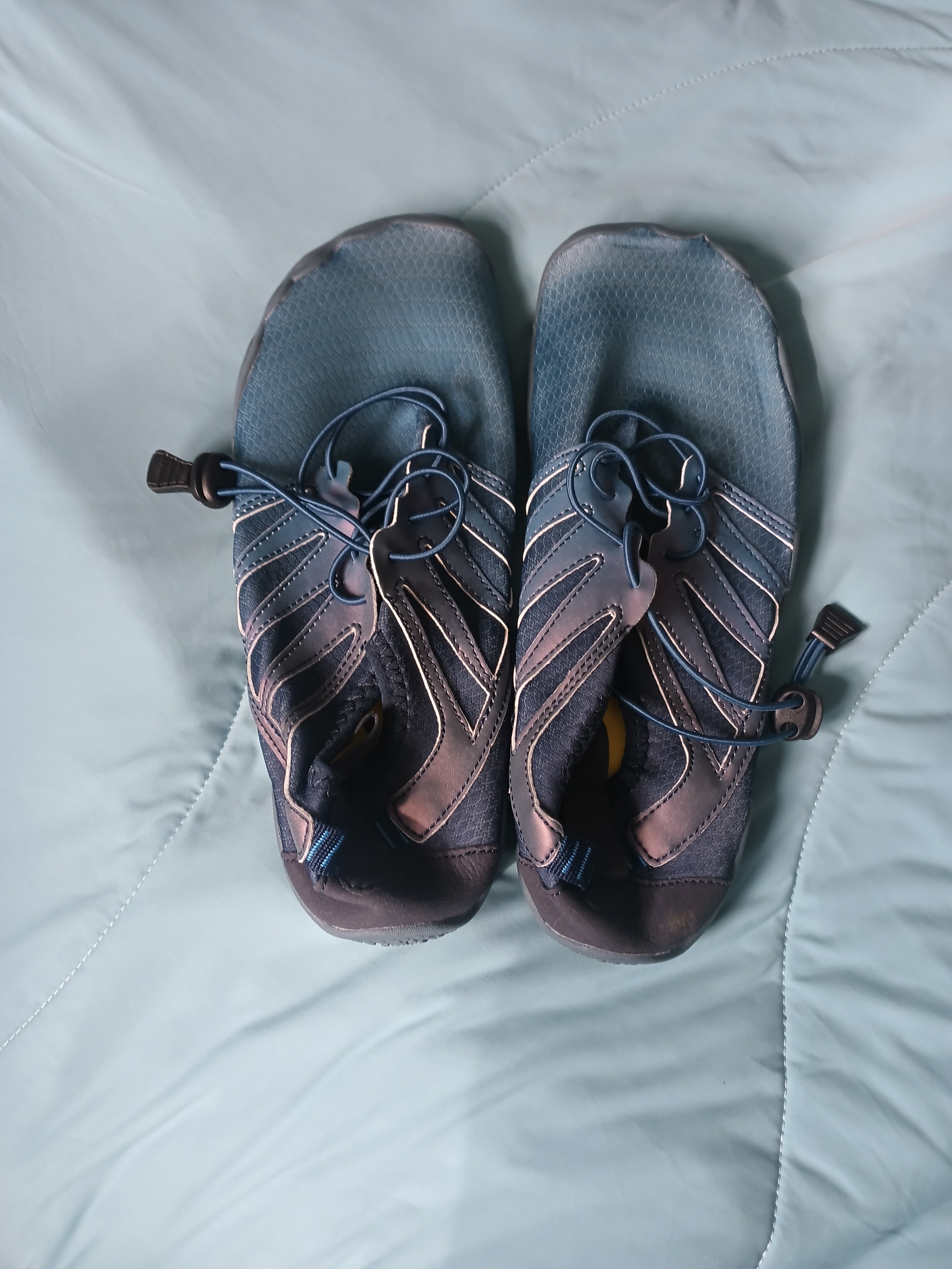
With my prolonged time off work (more here if you’re interested), I seem to be ahead of the barefoot curve and have found wearing my normal trainers – for walking or running – has been giving me knee and calf pain. Ditto for my trail shoes with a blister on the heel from too-short socks. Going in for 5k in my new shoes seemed like a recipe for posture problems, but I have done 5k before (Chopwell parkrun) in my hiking sandals previously without any issues. My memory of the Washington 10k (last run in 2018), was of gravel tracks, fields and woodland stretches – but not all that different to Chopwell. So. Sandals it is.

Decision 2 – Further Race Day Footwear, or Not:

We arrived at St. Robert’s in Washington (as a hosting venue, this was excellent!) for race number collection, and outside was a demo station for Scott trail shoes. Fen had only brought one pair of trainers with her – she has road-runners – so borrowing a pair would allow her to a) try out some fancypants trail shoes and b) have dry trainers for the drive home. The first niggle: should I also get some trail shoes? It’s wet out and my feet might freeze…but I haven’t bought any socks with me, so I’ll probably get blisters again, and no-one will want to wear them again after I’ve had bare feet in them. No, we’ll stick with the sandals.

Mile 1:

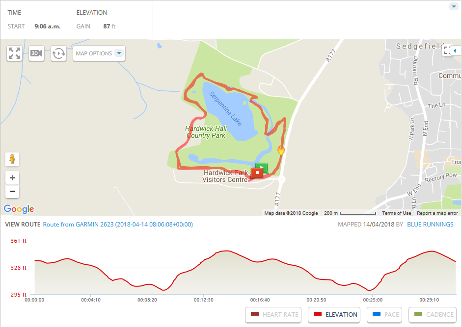
We headed off to the starting area for the launching of the 5k runners, starting at the back because we knew we were going to be walking stretches of it and some areas can be narrow. Initially, all went to plan: we headed off down the road to the aid station and the bridge across the river without hiccup. We made it up the first incline along the road and took the stile into the first of the woodland stages. All well so far, a little muddy but passable, we’re keeping tucked into the left as the faster 10k runners come past us. Everyone obviously having a wonderful day out in the mizzle.

Read the rest of this entry »
Leave a comment »

National Trust Dusk Run – Wallington

We have an annual tradition since moving into our house regarding Hallowe’en. It started in the first year when we’d literally just got the keys and hadn’t really moved anything in yet. We were painting the living room in our empty house when we heard the first trick-or-treaters moving up the road. We used to live in a small flat in a cul-de-sac and hadn’t had them so we hadn’t really clocked the significance of Hallowe’en to house dwellers. We did the incredibly adult thing of turning all the lights off and hiding below the sill-level of our curtain-less front windows until they moved on as we had absolutely nothing to give them!

P1000928

Since then, it’s sort of become tradition to hide with two exceptions – one where I was home alone, again with no sweets in the house (we’d probably eaten them all) and made a big batch of chocolate chip cakes in sandwich bags; these were oddly well received and the kids skipped on up the road swinging them and singing ‘choc chip cake, choc chip cake’ but god knows what the parents thought of them bringing home-baked goods back with them. The other was when we again forgot it was Hallowe’en and had ordered a pizza for delivery…so we had to hide in the house while also peering round the blind for the food chap! Very adult, mature and in the spirit of the thing I’m sure you’ll agree.

This year, Operation Hide-Away was again a go (we have curtains now!) except I’d also seen that Wallington Hall near Morpeth were doing a Dusk Run that evening; a trail run round a wooded estate in the dark? Yes, please! I’m still not up to the mileage I’d like to be so have missed a lot of races this year (or been wiped out by doing them!) so a casual 5k is just what the running soul needs right now 🙂

Untitled

I had guesstimated I would need to be wheels turning by 17:10 to get there – when I checked earlier in the day Google Maps said 40 mins to get there, which would still give me 10 mins to find people. I had not taken into account that leaving anywhere around 5pm would mean I hit rush-hour home traffic for most of the first half of the route. I did leave at 17:10 as it happened, and I flung myself into Wallington at 18:02. Not a headtorch in sight. I decided I had to at least try and find people, having come all the way there and looking forward to it all week – but not being hugely familiar with Wallington in daylight let alone the dark, had no idea where I was going. I found a sneaky path round the back of the cycle hut which brought me onto the road fronting the square. I heard voices! Fortunately, as they were waiting for one of their guide runners, I found everyone under the arch and was just in time to join them!

I really enjoyed this run – the lead runner works at Wallington and as such we got a guided tour of the site as well as a guided run route. We checked out a currently-being-excavated water mill from the early 1800’s, looked for white-tipped crawfish and otters in the Wansbeck when we crossed it, snuck over the wall of the walled garden, visited the “netty” (toilet to us non-Geordies but now used for picnics!), checked out the wildlife hide, saw videos of the local red squirrels, and saw the ice house for the main house where the family silver was hidden in WW2 incase the Nazis invaded!I’m really keen to go back in daylight and do it again where I can see a bit further than the range of my headtorch! The enthusiasm of our guides also really helped bring Wallington’s grounds to life, even in the dark.

Photo0266

This run only cost me £5 to attend – and as such I wasn’t expecting to get any keepsakes for attending. Our lead guide had a very bright light on a carabiner clipped to his bag I was considering asking where he had bought it from, so was pleasantly surprised to be presented with one from said bag with the other runners at the end before we all headed off for respective cars and beds. It’s really bright and probably worth the fiver on its own!

I do like having the local National Trust site pages on my facebook feed – you never know quite what’s going to come up and I’ve had some nice surprise little adventures through them 🙂 Looking forward to whatever the next one may be 🙂

map

You can download the GPX route file for this run from my Dropbox account here.

1 Comment »

parkrun – Durham

For information on this parkrun course, see the official parkrun page below:

http://www.parkrun.org.uk/durham/

This is a single-lap parkrun – not a huge number of those about! It’s quite out and back loopy, and covers a mix of terrains – we ran on gravel paths at the start, the outside of the rugby fields (stay outside the paint marks!) and onto the riverside path for a long stretch up to the bridge and back along the other side to the finish at the pavillion.

Durham had pacers for the event I went to, and I got the impression this was a moderately regular occurrence. I was trying to beat the 30min pacer, and while I’d left him a comfortable distance behind after the first mile, he was right behind me just before I came across the bridge – but the pace variance was me not him! He was bob-on for the 30 min marker 🙂

There’s plenty of parking at the sports centre near the start, as well as toilets and a track if you fancy a warm-up lap, but the finish is literally about 0.75 mile from the start. I’d pushed myself to get round in the time I wanted and was ready for a rest when I’d finished but when walking it felt like a loooong way back to the car. It is a pretty little woodland walk, and I did see a weasel, which was cool, but factor it in for your times if you’re in a rush to get home afterwards!

My GPS map for this route:

Durham

You can download the GPX route file for this course from my Dropbox account by following the link below:

GPX file for Durham parkrun

Course first completed 23-06-2018

Leave a comment »

parkrun – Pennington Flash

For information on this parkrun course, see the official parkrun page below:

http://www.parkrun.org.uk/penningtonflash/

This parkrun involves three laps of a small part of the grounds at Pennington Flash. There’s one hilly bit – not too long – and the rest definitely counts as ‘undulating’ to flat; not the flattest I’ve done but a long stretch from hilly. It’s worth noting that there is a reasonable walk from the carpark – allow 5-10 mins, and there is a parking charge at the main carpark (it’s a good size though – you should find a space fine). There is a free carpark at the entrance to the park, but it’s 1 mile walk/run from there to the start line, so factor this in if you’re planning on taking that option. Toilets available at the carpark and a lovely spot for birdwatching after your run!

30821794_2042586912623193_8143611890015744067_o

My GPS map for this route:

Pennington Flash

You can download the GPX route file for this course from my Dropbox account by following the link below:

GPX file for Pennington Flash parkrun

Course completed 21-04-2018

Leave a comment »

parkrun – Sedgefield

For information on this parkrun course, see the official parkrun page below:

http://www.parkrun.org.uk/sedgefield/

This parkrun in Sedgefield involves 2 laps of Hardwick Park; it’s mostly flat and runs around a lake but has one small hill about 2/3’s of the way round – fine on the first lap, a bit of a stickler on the second I found! There was plenty to see on the way round – a mix of wildlife and more manmade things of interest so it’s an easy one to just kick back and enjoy if you’re not going for a time 🙂

There’s plenty of parking – normally a charge but if you put your spare barcode in the windscreen it’s FREE until 11am, which gives you plenty of time to pop to the loos (also open before the start) and go the coffee shop for a breakfast bap or a wide selection of yummy cakes!

My GPS map for this route:

Sedgefield

You can download the GPX route file for this course from my Dropbox account by following the link below:

GPX file for Sedgefield parkrun

Course completed 14-04-2018

Leave a comment »

parkrun – Woodbank

For information on this parkrun course, see the official parkrun page below:

http://www.parkrun.org.uk/woodbank/

This parkrun in Stockport covers ground in two parks – Woodbank and Vernon, and starts at the top of a hill…you can see where this is going?! There’s a tough little uphill kick at the end of the Vernon Park loop (which you do twice) as you can see on the elevation profile below!

There’s limited parking near the start-line – maybe 20 cars? – so get there early if you’re planning on using it, or there’s a bigger public carpark nearby. Average number of runners is 120 per week, so no fear of being on your own in a small group of elite runners! The whole route takes place on tarmac, except for one small section of cobbles as you crest the top of the hill coming out of Vernon Park.


My GPS map for this route:

Woodbank

You can download the GPX route file for this course from my Dropbox account by following the link below:

GPX file for Woodbank parkrun

Course completed 31-03-2018

Leave a comment »

parkrun – Gibside

For information on this parkrun course, see the official parkrun page below:

http://www.parkrun.org.uk/gibside/

This is a tough little course – which was evident from the smaller number of runners who braved it despite it being a clear and sunny morning (though that may also have been the summer holidays coming into play). It’s a tough little course with some long and serious hills and an elevation of 311ft according to my GPS watch. There’s flatter stretches at the top of each hill, but you don’t get to go down much until the very end where you come right back down and then along the long flat of The Avenue back to the finish. You leave by the Walled Garden, head out on a loop at the top of the estate, and finish on a there-and-back part way up the hill to the highest point on Gibside’s grounds before spinning round and heading back to the Walled Garden again for the finish.

You can view a map of the estate (which is worth a visit even just for a walk round and a teacake) by clicking the link below.

Gibside Estate Map from National Trust

Runner’s View video tour of Gibside parkrun, taken 29-07-17 with a head-mounted (and therefore somewhat bouncy-recording!) Apeman camera.

Local facilities:

  • Café (takes cash or card)
  • Toilets

My GPS map for this route:

Gibside.png

You can download the GPX route file for this course from my Dropbox account by following the link below:

GPX file for Gibside parkrun

Leave a comment »

parkrun – Preston: Cuerden Valley

For information on this parkrun course, see the official parkrun page below:

http://www.parkrun.org.uk/cuerdenvalley/

This route involves 2 laps of 2 loops around Cuerden Valley Park – and several hills! The one to the finish is rather mean!!!

Runner’s View video tour of Cuerden Valley parkrun, taken 15-04-17 with a head-mounted (and therefore somewhat bouncy-recording!) Apeman camera.

My GPS map for this route:

Cuerden Valley

You can download the GPX file for this course from my Dropbox folder here:

Cuerden Vally parkrun GPX file

Leave a comment »

parkrun – Consett: Blackhill

For information on this parkrun course, see the official parkrun page below:

http://www.parkrun.org.uk/blackhill/

This route involves 3 laps around Blackhill Park – you’ll get the biggest hill out of the way at the start to really open your lungs up or completely wipe out your legs depending on how you feel about starting your run with a monster climb! There’s several hills of mixed length and gradient on this course, but a lovely long downhill for a strong finish. It’s generally thought of as one of the toughest in the area, but it’s excellent for training your legs up ready for cross-country or for a pb on a flat course!

GPS map:

Blackhill

You can download the GPX file for thise courses from my Dropbox folder here:

GPX file Blackhill

Leave a comment »

parkrun – Prudhoe: Riverside

For information on this parkrun course, see the official parkrun page below:

http://www.parkrun.org.uk/prudhoeriverside/

This route involves 2 laps around a local feature known as the Spetchells – fortunately it goes round them rather than over them as there’s some serious climbing involved to get to the top! There’s a bit of an incline round the back of this one, but nothing serious and it’s generally considered a flat course and good for setting a parkrun pb on.

GPS map:

Prudhoe

You can download the GPX file for thise courses from my Dropbox folder here:

GPX File Prudhoe Riverside

Leave a comment »